
 NavNet MFDs
 Radars
 Fish Finders & Transducers
 GPS & Chart Plotters
 Autopilots
 Navigation
 Sonars
 Commercial
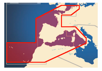
MM3-V46-MWN
No Longer Available
MSRP: $500.00
EU INLND WTRS-VMW
Chart RegionsEurope
Chart TypeNavionics Datacore or Vector or 3D Bathy Data or Satellite Photo
Prices and Specifications Subject to Change Without Notice.
All prices shown are in USD. Prices are valid in US and Canada only.
Vector Charts, 3D Data and Standard Resolution Satellite Photography - Western Europe Inland Waterways
This Chart Pack includes vector charts, 3D data and standard resolution satellite photography for Western Europe Inland Waterways. Navionics chart data is used and converted to the TimeZero format. Note that you will need to purchase an unlock code to view this chart data. Unlock Codes for NavNet must be purchased through an Authorized Furuno Dealer.
To purchase this chart pack for NavNet, you will need to provide your NavNet system ID to your local authorized Furuno dealer. The system ID can be located under the “My NavNet” menu on your NavNet system.
Click here to download chart from MapMedia.com. Note that you will need to purchase an unlock code to view this chart data.