
 NavNet MFDs
 Radars
 Fish Finders & Transducers
 GPS & Chart Plotters
 Autopilots
 Navigation
 Sonars
 Commercial
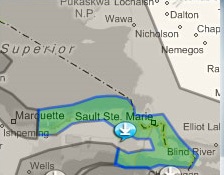
MM3-USS-G03
MSRP: $0.00
Satellite Photography for SE Lake Superior & NW Lake Huron
Chart RegionsUSA Central or USA
Chart TypeSatellite Photo
Free ChartsSatellite Photos
Prices and Specifications Subject to Change Without Notice.
All prices shown are in USD. Prices are valid in US and Canada only.
Satellite Photography for SE Lake Superior & NW Lake Huron
This satellite photo for the USAGL03HSAT01 area shown above. It covers SE Lake Superior and NW Lake Huron and includes:
- Straits of Mackinac
- Au Train Bay
- St. Mary's River
- De Tour River
We recommend that you request this data on an SD card from your local Authorized Furuno Dealer. A fee may apply for the dealer to provide you with the data on an SD card.
Optionally, you can download the satellite photo. Note that the file size is approximately 1.5 GB, depending on your connection speed and available bandwidth this file may take awhile to download. If you wish to download this satellite photo area, click on the link below.
Caution: When downloading DO NOT modify file names or extensions.
>> Download Sat Photo area USAGL03HSAT01 - approx. 1.5 GB
Areas displayed are for guidance only and do not reflect exact coverage.