
 NavNet MFDs
 Radars
 Fish Finders & Transducers
 GPS & Chart Plotters
 Autopilots
 Navigation
 Sonars
 Commercial
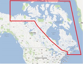
MM3-NAT-001
MSRP: $0.00
3D Data for NE US and Canada
Chart RegionsUSA East Coast or Canada or USA
Chart Type3D Data or 3D Bathy Data
Free ChartsCharts
Prices and Specifications Subject to Change Without Notice.
All prices shown are in USD. Prices are valid in US and Canada only.
3D Data for NE US and Canada
This is the 3D Topographic/Bathymetric Data for the Northern and Eastern Canadian coastline.
We recommend that you request this data on an SD card from your local Authorized Furuno Dealer. A fee may apply for the dealer to provide you with the data on an SD card.
Optionally, you can download the data. Note that the file size is large and will take time to download, depending on your connection speed and available bandwidth. To view instructions on how to download the file and upload to NavNet, please click on the Manuals/Documents Tab. If you wish to download this satellite photo, click on the link below.
Caution: Only replace this data if you have accidentally deleted it from your NavNet system, or if you need to update to Ed 6. When downloading DO NOT modify file names or extensions.
>> Download SDNA01TIN01 area - approx. 633 MB
Areas displayed are for guidance only and do not reflect exact coverage.